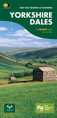
Hiking map - Yorkshire Dales South-East XT40 | Harvey Maps - Ultramap

Price
Regular price 1790 €
Regular price Sale price 1790 €
/
  • In stock in France and in the UK
    Shipped within 24 to 48h from the warehouse closest to you
  • Free returns (*)
  • Real-time stock levels
  • Cartovia Guarantee – Delivery issue?
    We resend immediately upon receiving a simple photo.
  • In stock, ready to ship
  • Backordered, shipping soon
Tax included.

Frequently bought together:

This map by Harvey Maps covers Yorkshire Dales South-East.

Ultralight, compact hiking map.

Detailed map for runners and walkers of the south eastern part of the Yorkshire Dales National Park.

Includes Pen-y-ghent, Malham Cove, Wharfedale and Nidderdale, Settle, Skipton and Grassington.

  • Use without a map case: tough and 100% waterproof.
  • Opens directly to either side of the sheet.
  • Rights of way are shown.
  • Covers a large area in a handy, pocket-sized format.
  • Retains the advantages of the larger formats.

The collection offers maps of regions in England, Wales and Scotland.


ISBN/EAN : 9781851375844
Publication date: 2016
Scale: 1/40,000 (1cm=400m)
Printed sides: both sides
Folded dimensions: 7.3 x 15.2cm
Unfolded dimensions: 30.4 x 87.5cm
Language(s): English
Weight: 70 g