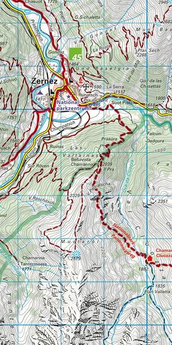
Hiking map No. 98 - Unterengadin NP, Lower Engadine (Switzerland) | Kompass

Price
Regular price 2095 €
Regular price Sale price 2095 €
/
  • Shipped within 24 to 48h from our warehouse in France
  • Free returns (*)
  • Real-time stock levels
  • Cartovia Guarantee – Delivery issue?
    We resend immediately upon receiving a simple photo.
  • Low stock - 2 items left
  • Backordered, shipping soon
Tax included.

Frequently bought together:

The Kompass Lower Engadine and Swiss National Park hiking map is ideal for hiking, cycling, and outdoor activities in one of the most pristine regions of the Swiss Alps.

Easy to read and rich in information, it allows you to plan your routes and navigate effectively in the field thanks to detailed and regularly updated cartography.

📌 Features

  • Scale: 1:40,000
    • 1 cm on the map corresponds to 400 m on the ground
  • Detailed cartography including:
    • official hiking trails with names and numbers
    • cycling and mountain biking routes
    • via ferrata
    • huts and inns
    • parking lots
    • public transport (bus and train)
    • ski touring routes and cross-country ski trails
    • springs and swimming spots
  • Relief represented by:
    • contour lines
    • vegetation
    • rock drawings
    • hill shading

🧭 A map designed for outdoor activities

Thanks to its precise cartography and wealth of tourist information, this map is particularly suitable for:

  • hiking,
  • alpine trekking,
  • cycling and mountain biking,
  • nature observation,
  • planning excursions in the Swiss National Park.

🌍 Covered region

Located in the canton of Graubünden, the Lower Engadine is one of the most beautiful alpine valleys in Switzerland. The region is home to the Swiss National Park, the oldest national park in the Alps, renowned for its pristine landscapes, wild fauna, and vast natural spaces.

You will discover, among others:

  • the wild valleys of the Engadine,
  • the alpine forests and high-altitude pastures,
  • the traditional Engadine villages,
  • the Piz Linard and surrounding peaks,
  • the trails crossing the Swiss National Park.

An ideal territory for mountain lovers seeking nature and wide-open spaces.


ISBN/EAN : 9783991545750
Publication date: 2026
Scale: 1/40,000 (1 cm = 400 m)
Folded dimensions: 11 x 19cm
Language(s): German
Weight: 115 g