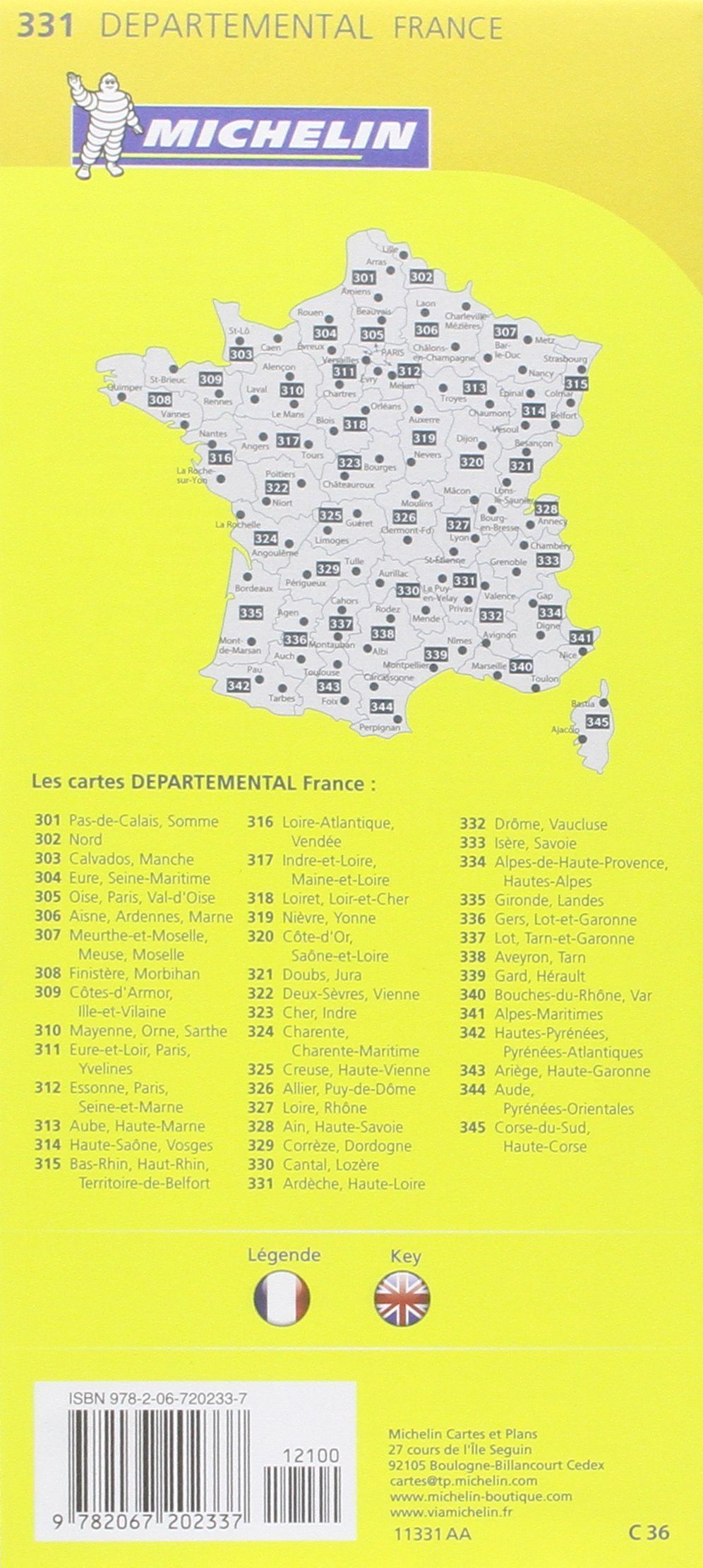
TOP 25 Map No. 2935 OT - Le Chambon-sur-Lignon, Saint-Agrève | IGN

Price
Regular price £1300
Regular price Sale price £1300
/
  • Ships within 5 to 8 working days
    (Currently in transit to our warehouse in France)
  • Cartovia Guarantee – Delivery issue?
    We resend immediately upon receiving a simple photo.
Tax included.

Often purchased together:

TOP 25 topographic map no. 2935OT of Chambon-sur-Lignon and St-Agrève published by IGN.

This hiking map features contour lines spaced 10 meters apart and a detailed legend (vegetation, rocks, communication routes down to the smallest path, buildings down to the shed, woods, isolated tree, river, spring, etc.).

Marked trails and tourist information are indicated. Scale 1/25,000 (1 cm = 250 m).

Municipalities covered: Le Chambon-sur-Lignon, Saint-Agrève, Lalouvesc, Tence, Nozières, Désaignes, Labatie-d'Andaure, Le Mas-de-Tence, Mars, Satillieu, Rochepaule, Mazet-Saint-Voy, Montregard, Chenereilles, Saint-Jeure-d'Andaure, Saint-Pierre-sur-Doux, Saint-André-en-Vivarais, Saint-Bonnet-le-Froid, Pailharès, Saint-Symphorien

Places to discover: Monts d'Ardèche Regional Natural Park, Mont Chaix, Grand Felletin, Chirat Blanc or Suc du Barry, Monts du Vivarais, Vallée de la Cance, Château de Rochebloine


ISBN / EAN : 9782758557487
Date de publication : 2025
Echelle : 1/25,000 (1cm=250m)
Impression: front
Dimensions plié(e) : 24 x 11cm
Dimensions déplié(e) : 132 x 96cm
Langue : French, English, German
Poids : 89 g