Topocarte hiking map - Tour of the Ossau Valley | FFRandonnée

Price
Regular price $2200
Regular price Sale price $2200
/
  • Shipped within 24 to 48h from our warehouse in France
  • All-inclusive price: customs duties are already paid by Cartovia
  • Free returns (*)
  • Real-time stock levels
  • Cartovia Guarantee – Delivery issue?
    We resend immediately upon receiving a simple photo.
  • In stock, ready to ship
  • Backordered, shipping soon
Tax included.

Frequently bought together:

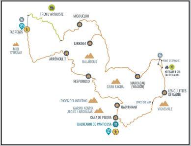
The Tour of the Ossau Valley Topocarte map follows the GRP® on a 99 km loop from Louvie-Juzon. With 6,400 m of elevation change, this demanding route crosses low- and mid-altitude mountains, passing upland pastures, granite rocks, forests, peaks and lakes.

The itinerary is specifically designed for bivouacking: three stages have no accommodation but offer bivouac sites. The main places mentioned are the Pyrenees National Park, Ossau Valley, Pic du Midi d’Ossau and Pau.

  • Detailed IGN mapping at 1:25,000.
  • 2025 update: improved readability, softer four-colour printing and reinforced, rain-resistant paper.
  • QR code providing access to the GPX track, selected accommodation and useful contacts through MaRando.
  • Compact, practical format to make multi-day hiking easier.


ISBN/EAN : 9782751413674
Publication date: 2025
Scale: 1/25,000 (1cm=250m)
Printed sides: both sides
Folded dimensions: 25 x 10.7 x 0.3 cm
Language(s): French
Weight: 80 g