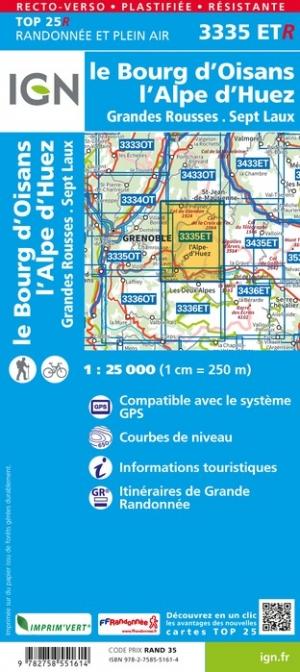
TOP 25 Map No. 3335 ETR (resistant) - Bourg d'Oisans & Alpe d'Huez (Alps) | IGN

Price
Regular price $2900
Regular price Sale price $2900
/
  • Shipping within 24 working hours from our warehouse in France
  • Choisissez votre mode et vos frais de livraison à l’étape de paiement, avant de valider.
  • Retours gratuits (*)
  • Stocks en temps réel
  • Low stock - 1 item left
  • Backordered, shipping soon
Tax included.

Souvent achetés ensemble :

Top 25 map of the Alpe Huez region, published by IGN. This detailed map extends from the city of Le Pleynet (north) to the village of Oisans (south) and which includes the massif of the Grandes Redheads, seven Laux, the passes of the Glandon and Horseshoe.

Hiking map with space curves spaced 10 meters and detailed legend (vegetation, rocks, streams etc ...). Indication of hiking trails. Scale 1 / 25,000 (1 cm = 250 m).

GPS compatible map.

- This map is printed on a laminated support and tearing resistant , ideal for the practice of outdoor activities.

- Duplex map: a reduced footprint that facilitates handling.


ISBN/EAN : 9782758551614
Publication date: 2021
Scale: 1/25,000 (1cm=250m)
Printed sides: both sides
Folded dimensions: 23.6 x 11.2 x 0.5cm
Unfolded dimensions: 50 x 132cm
Language(s): French, English, German
Weight: 81 g