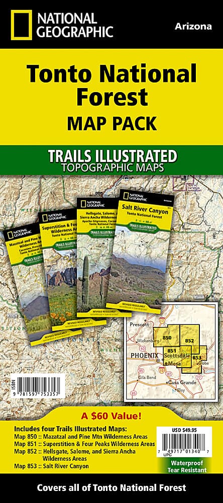
One of the most visited urban forests in the United States, with approximately 5.8 million visitors annually, Tonto National Forest spans nearly 3 million acres of diverse terrain just outside Phoenix, AZ. Tonto encompasses a wide variety of vegetation, from cactus-studded desert to pine-forested mountains, and offers numerous recreational opportunities year-round. Each map contains easy-to-read trails, numbered forest roads, campsites, access points, scenic points of interest, and important facilities. Here are some of the highlights of these four maps: Mogollon Rim, Superstition Wilderness, Mazatzal Wilderness, Pine Mountain Wilderness, Four Peaks Wilderness, Hellgate Wilderness, Salome Wilderness, Sierra Ancha Wilderness, Salt River Canyon, Bartlett Lake, Horseshoe Lake, Saguaro Lake, Canyon Lake, Apache Lake, Roosevelt Lake, Verde River, Salt River, The Rolls and Bulldog Canyon ATV Areas, and much more.
The Tonto National Forest Map Pack includes:
Map No. 850: Mazatzal and Pine Mountain Wilderness Areas [Coconino, Prescott, and Tonto National Forests]
Map No. 851: Superstition and Four Peaks Wilderness Areas [Tonto National Forest]
Map No. 852: Hellsgate, Salome, and Sierra Ancha Wilderness Areas [Apache-Sitgreaves, Coconino, and Tonto National Forests]
Map No. 853: Salt River Canyon [Tonto National Forest]
These topographic maps are waterproof and tear-resistant.
Scale 1:70,000. The topographic maps are waterproof and tear-resistant.