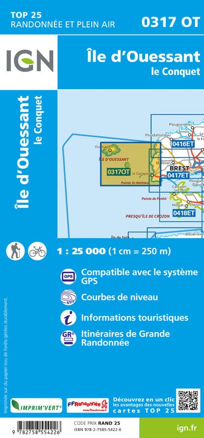
TOP 25 map No. 0317 OT - Ouessant Island, Le Conquet | IGN
- Shipping within 24 working hours from our warehouse in France
- Shipping method and fees are shown at checkout
- Free returns (*)
- Real-time stock levels
- In stock, ready to ship
Over 19,500 maps 🗺️ and travel guides, hiking maps, posters, globes, and décor items in stock!
Rated Excellent ⭐️ on Trustpilot — 9,000+ reviews from explorers and map lovers worldwide.
Explore the world, one map at a time 🗺️
TOP 25 topographic map No. 0317OT of the island of Ouessant and Conquet published by IGN.
Very precise, it contains all the details existing on the ground: communication routes and paths, constructions including sheds, woods, isolated trees, rivers, sources. Without forgetting the representation of the relief by contour curves. Marked trails and tourist information are also represented.
Municipalities covered: Ile-Molene, Lampaul-Plouarzel, Lanildut, Ouessant, Porspoder, Trebabu
Places to discover: Armorique Regional Natural Park, Passage du Fromveur, Ile Molene, Ile de Beniguet, Pointe St-Matthieu, Pointe de Corsen, Ile d'Ouessant, Phare de la Jument, Phare de Trezien, Phare du Stiff, Abbey, Iroise Nature Reserve, Creac'h Lighthouse, Notre-Dame de Bon Voyage, Aber Ildut Lighthouse
ISBN/EAN : 9782758554226
Publication date: 2024
Scale: 1/25,000 (1cm=250m)
Printed sides: front
Folded dimensions: 23.6 x 11.2 x 0.5cm
Unfolded dimensions: 96 x 132cm
Language(s): French, English, German
Weight:
89 g
The exclusive newsletter for travel and discovery enthusiasts!